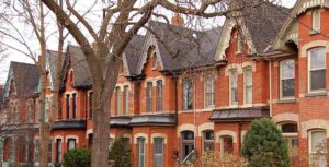
The Cabbagetown HCD Advisory Committee has compiled information on each house in Cabbagetown on this website. Click Property Search and put in your home’s address and street name, but don’t add St. or Ave. to the search.
Most of Cabbagetown is already designated a Historical Conservation District and the southwest area is under study for designation. The HCD guidelines set restrictions on alterations of the portions of homes that are visible from the street. General details can be found here. The plans for each area can be viewed on-line here.
The Cabbagetown Preservation Association
Another great source of information about Cabbagetown’s history and details of how to get heritage restoration permits and grants is the Cabbagetown Preservation Association website.
The CPA runs several educational programs that aim at interpreting and understanding Cabbagetown’s heritage – architecture, people, streetscapes and landmarks, including two heritage cemeteries and a turn-of-the 20th century farm.
Several other local organisations now focus on Cabbagetown – you’ll find a list and links on the CPA’s Contact Us page. The CPA has adopted a principle of collaborative advocacy which expresses the desire to partner with other organisations whenever appropriate to build a community network.
Digging deeper
The information in our property compendium was researched at the City of Toronto archives which is at 255 Spadina Road. The archives have specialists on duty who can help you access documents and photos and provide further information. Some of the archive materials are also searchable on-line.
The City’s has listed and designated properties as historically significant in an Inventory, originally commenced in the 1960’s by the Toronto Historical Board. You can search it on-line here.
If your property is identified as heritage designated or listed, the city’s Heritage Preservation Services may be able to direct you to more documentation. You can search here.
Historic photographs
There were very few original photos taken of the residential blocks in Cabbagetown in its early days, but the city archives has collections of images taken by photographers and city works departments and a number include Cabbagetown street scenes. You can do a search at the city historical archives. Many fascinating digital images have been posted on-line.
Who lived there
Tax records at the archives indicate who is listed as the owner in each year, but not necessarily who lived in the home.
You can also search city directories to find who was listed as the resident for any year.
Toronto city directories were produced as early as 1833 and have been annual since 1861. The most useful are what are known as Might’s Directories, after J. M. Might, manager of the publishing company which produced it. They allow searches by name as well as by street address. A competing directory edition was produced by the R.L. Polk Co. Additional information and statistics in the directories, including advertisements, are also extremely interesting.
The Toronto Public Library has digitally scanned many of the directories from 1833 to 1969 and they can be searched on-line.
The 1891 Might City Directory is of particular value due to the fact that it was published soon after the most active period of building of houses in what are now downtown neighbourhoods. It contains an alphabetical list of all business firms and private citizens, and a separate listing alphabetically of streets and the names and names and occupations of the resident at each address.
Anyone have blueprints?
Original blueprints from a century or more ago are virtually impossible to find. However, many of the houses in Cabbagetown were built between 1870 and 1900 from pattern books imported from England and Scotland and adapted to the size of the site. Several reproductions of Victorian pattern books are in the Toronto Public Library collection and can be requested at the Toronto Reference Library.
Architects who specialize in historical renovation are familiar with the features of homes of this era.
Other resources
The Atlas of the City of Toronto and Vicinity, sometimes referred to as the “Goad’s Atlas”, (after Charles E. Goad, Civil Engineer, who produced them), books of large-scale detailed maps, of The City of Toronto and Vicinity, “From Special Survey founded on Registered Plans and showing all Buildings and Lot Numbers”. The maps show the size, shape and construction material of each building in the city (brick buildings in red and wood frame ones in yellow). The Goad’s Atlases were not published every year, but from time to time, with the 1884, 1890 and 3-volume 1910 editions of particular interest. They can be searched on-line here.
There are also a number of other resources, such as Mike Filey’s books, and a number of landmark volumes, such as Robertson’s Landmarks, a 6-volume set, and Toronto Called Back which contain large amounts of information, including photographs, about the City.


